By now you’ve likely heard of Torres del Paine, Chile’s most visited national park. It’s vast wonderland at any time of year, which has stands of native trees, guanacos (a relative to the llama), and the occasional shy puma along its vast glacial valleys. But in January and February, crowds can turn parts of this park—especially the W, the most often-hiked trek—into a bit of a traffic jam. It can be hard to get a sense of peace and spaciousness, spying other hikers at every overlook of the jagged Glacier Grey or the turquoise and milky lakes that dot the park.
So what’s a traveler to Patagonia to do? First of all, there are some lesser-traveled hikes within the park, like parts of the O, or “the circuit,” as well as some more untrammeled areas of the park. Or you could skip Torres del Paine altogether, and try one of these other, lesser-known and somewhat wilder Patagonian hikes. Here are five that we at Upscape suggest.
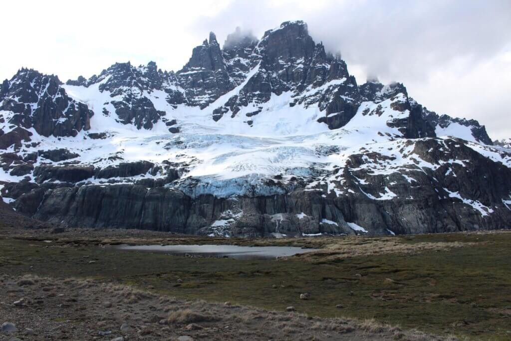
1. Cerro Castillo
Along the Carretera Austral, Chile’s wildest road, is the jagged basaltic formation called Cerro Castillo, named for the mountain’s spires, which make it look like a castle. The highway is the only access for much of untamed Aysén, as this region is called. The 2,675 meter high mountain of Cerro Castillo predominates the landscape to the west of the “carretera,” just a few hours’ drive south from Coyhaique, and gets few visitors, though numbers are rising. It’s easy enough to take a day hike here, but there is also a four-day circuit.
The four-day, 43 km hike is on rugged terrain, partially through lenga (artic beech) forests, and hikers have a high possibility of seeing interesting wildlife, such as the huemul, an endangered deer endemic to Patagonia. The Cerro Castillo hike has creek and river crossings, three different glacier sightings, and views over the Río Ibañez, as well as the Hudson Volcano, whose last major eruption in 1991 resculpted river routes and left a swath of destruction in its path. One major highlight of this hike is the lake named for the hill itself, Laguna Cerro Castillo, a prime camping spot between days two and three of this epic hike. For the non-hiking inclined, there is also horseback riding available along parts of this route. Don’t miss eating a giant sandwich on your way in or out of this hike at La Cocina de Sole, a bus-turned “diner” that serves hot tea and huge sandwiches to many a traveler.
2. Dientes de Navarino
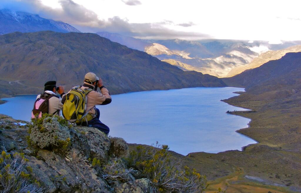
Below the Southern Cone, where the South American continent seems to end, is the Straight of Magellan, and on the other side of that, is the large island of Tierra del Fuego, shared by Chile and Argentina. Then comes the Beagle Channel and after that, the southernmost permanent human settlements in the world, on Isla Navarino. History buffs and naturalists may recognize the name, as Charles Darwin spent time on this island. The diminutive town of Puerto Williams is the center of all services on the island, and, lucky for hikers, it also has good access to the trailhead to the Dientes de Navarino, the mountain chain named for their jagged, teeth-like appearance. If you prefer your sleeping to take place within four walls, you can still do a lovely half-day hike up to Cerro Bandera, where the trail starts. Hardier explorers may instead choose the four or five-day trek through high passes over craggy peaks and to protected azure lagoons hidden deep in the mountains.
The total distance of the circuit is 53.3 km, which for a four-day route might seem a short distance, but with this rocky terrain and altitude gain, it might just be enough. Another indicator of the remoteness and difficulty might be that only a few hundred people (at most) hike this circuit in any given year. Swirling clouds, wind unchecked by any other landmass and changeable Patagonian climate provide the dramatic backdrop for these weather-battered, snowy passes. But the untrammeled beauty and blue-sky days more than make up for the unpredictable conditions. With fine weather and enough time, hikers sometimes extend their trip to a fifth day, to add one final lake, the Laguna de los Guanacos, which is at the base of Paso Virginia, in order to savor their time on this trek, and the wildness of uttermost Patagonia.
3. El Chaltén/Mount Fitz Roy
This part of Argentina’s Los Glaciares National Park is accessed from the postcard-sized town of El Chaltén, one of Argentina’s best-kept Patagonian secrets. At a different access point to the park, accessed from El Calafate, the calving face of the vast Perito Moreno glacier can be seen. The two parts of the park are accessed from different entrances.
On the drive to El Chaltén, a couple of hours from El Calafate, it’s hard to pull your eyes from the giant looming granite spires of Mount Fitz Roy, easily seen on a clear day. Mount Fitz Roy is located within the Southern Patagonian Ice Field, close to both the Chilean and Argentine borders. In the shadow of this impressive, 3359 meter-high mountain, there are several trails that can easily be stitched into a few days’ of good hiking and camping, with nothing like the crowds in Torres del Paine.
One element that makes these hikes substantially different from Torres del Paine is that many of them can be done as day hikes from the Poincenot campsite, which means coming back to the same spot at night, instead of portaging your gear within the park, though there are options for that as well. Highlights from this access point include the overlook to the Piedras Blancas glacier, as well as a hike up to the alpine-like Laguna de Los Tres, as well as the glacial Laguna Torre. You can double back from the Laguna de Los Tres to the Poincenot campsite, spend the night, and head out the next day towards Piedra del Fraile, past the sheer cliffs near Río Eléctrico, and looking upon the north face of Mount Fitz Roy, before heading back to the campsite. On a windy evening you can see the roiling clouds spilling over the lesser peaks of Mount Fitz Roy as the sun sets.
4. El Chaltén, Huemul Circuit
Probably the most grueling of the Torres del Paine alternatives, the Huemul Circuit, is just outside of the tiny town of El Chaltén, as are the hikes above, but at a different trailhead within Argentina’s Parque Nacional Los Glaciares. This hike is for experienced adventurers, and suggested gear includes a four-season tent, carabiners, harness, sandals and poles for deep river crossings and a whole lot of grit. Look out for local fauna, including the giant Magellanic woodpecker, the male of which is identified by his flaming red head. From the name of the trek, you might hope to see a huemul, a shy deer endemic to the region, but they are notoriously difficult to spot.
The first day of this trek is deceptively easy, and the last day is considered medium difficulty, but the two days in the middle will test your mettle. Diverse landscapes, views of the Mount Fitzroy massif and the Southern Ice Field are only some of the rewards. Others include the topaz-colored Lago Viedma, and the hanging glacier on hike’s namesake Cerro Huemul. The Viedma glacier is Argentina’s biggest, and several times larger than Perito Moreno, but significantly more difficult to visit. Challenges here include hiking on glacial moraine, knee or waist-high river crossings and a mountain pass called Paso del Viento (windy pass).
This four-day trek requires a guide or good orienteering skills, as it is largely un-signposted. Maps are available locally, or download one here.
5. Parque Patagonia
Parque Patagonia is part of the Tompkins Conservation legacy, founded by two former entrepreneurs, Kristine and the late Douglas Tompkins, to protect wide swaths of Patagonia. Their goals include helping endangered species to repopulate, and encouraging landscapes to recover after different human interventions. Particularly in recent years, as major companies have to exploit some of Patagonia’s riches, these protected lands grow in importance. Recent international opposition helped to quash a proposed dam project, which would have affected the Baker, Chile’s most voluminous river. The Tompkins’ conservation projects are part of what is helping to protect what is still one of the wildest places in the world.
Because of the ecological drive to keep these lands healthy and untouched, interventions are few and far between, which makes a visit to 650,000-hectare Parque Patagonia truly unique. There are three main ways people come to get to know this park, as a day visit as part of a trip down Chile’s lonely Carretera Austral (southern highway), on a multiple-day visit with different day activities, including hiking, mountain biking or bird watching, or finally, on a multi-day hiking.
For day hikes, there are several options, from the least challenging “La Confluencia” hike, which is where the Chacabuco and Baker rivers (see above) come together, through to the Lagunas Altas or Furioso trails, each of which is 14 miles. The Furioso trail is where hikers can see one of the park’s most photographed mountains, Cerro Kristine, while the Lagunas Altas trail climbs up a hill and loops around several alpine lakes. For overnight hikers, there is the Aviles Valley trail, which leaves this park to connect to a hike in the Jeinimeni Mountains, ending at the pleasant town of Chile Chico, known for its warm microclimate and as a consequence, as a paradise for fruit-lovers. Cherry, peach and plum trees dot the city, and line the central plaza.
This list was a hard one to compile. There are so many interesting multi-day hikes or single-day hikes that can be strung together in natural areas, reserves and parks within Chilean and Argentine Patagonia. You really couldn’t go wrong with any of them, so long as you’re well-equipped and in good hiking shape.